The brief
The Landscape Workshop was commissioned to prepare a Landscape and Visual Impact Assessment supporting a planning application for twelve bespoke five-star timber holiday lodges on gently sloping improved pasture near Pwllheli, on the Llŷn Peninsula. The site sits on the western flank of a minor ridge associated with the Afon Erch valley, at around 63m AOD, forming part of a larger agricultural field of pastoral grassland managed for grazing. The design brief called for a low-density, deliberately restrained scheme: timber-clad lodges in muted environmental tones, arranged in small informal clusters with generous open space between them, served by the existing highway access.
The landscape constraint, however, was significant. The site lies within the Llŷn and Ynys Enlli Registered Landscape of Outstanding Historic Interest, one of only 36 such landscapes in Wales and covering some 28,000 hectares of the Llŷn Peninsula west of the A499. The assessment had to engage seriously with the layered archaeological and historic fabric of Central Llŷn — hillforts, Neolithic burial chambers, Bronze Age cairns, medieval field boundaries, holy wells, post-medieval chapels — and with the dry-stone walls, cloddiau and ancient hedged enclosures that give the peninsula its distinctive grain.
The landscape and visual context
At national scale the site falls within NLCA 05: Tremadoc Bay, a predominantly rural lowland coastal landscape hemmed between Llŷn and Snowdonia, characterised by rolling pastoral farmland, small woodland copses and scattered dispersed settlement. Locally it sits within LCA 10: Central Llŷn as defined in the Gwynedd Landscape Guide — a landscape shaped by glacial deposits, historic field systems, prominent outlying hills such as Mynydd Cennin and Y Foel, and the buffer role it plays between the Llŷn AONB to the west and Eryri (Snowdonia) National Park to the east. Landscape value and sensitivity were both assessed as high.
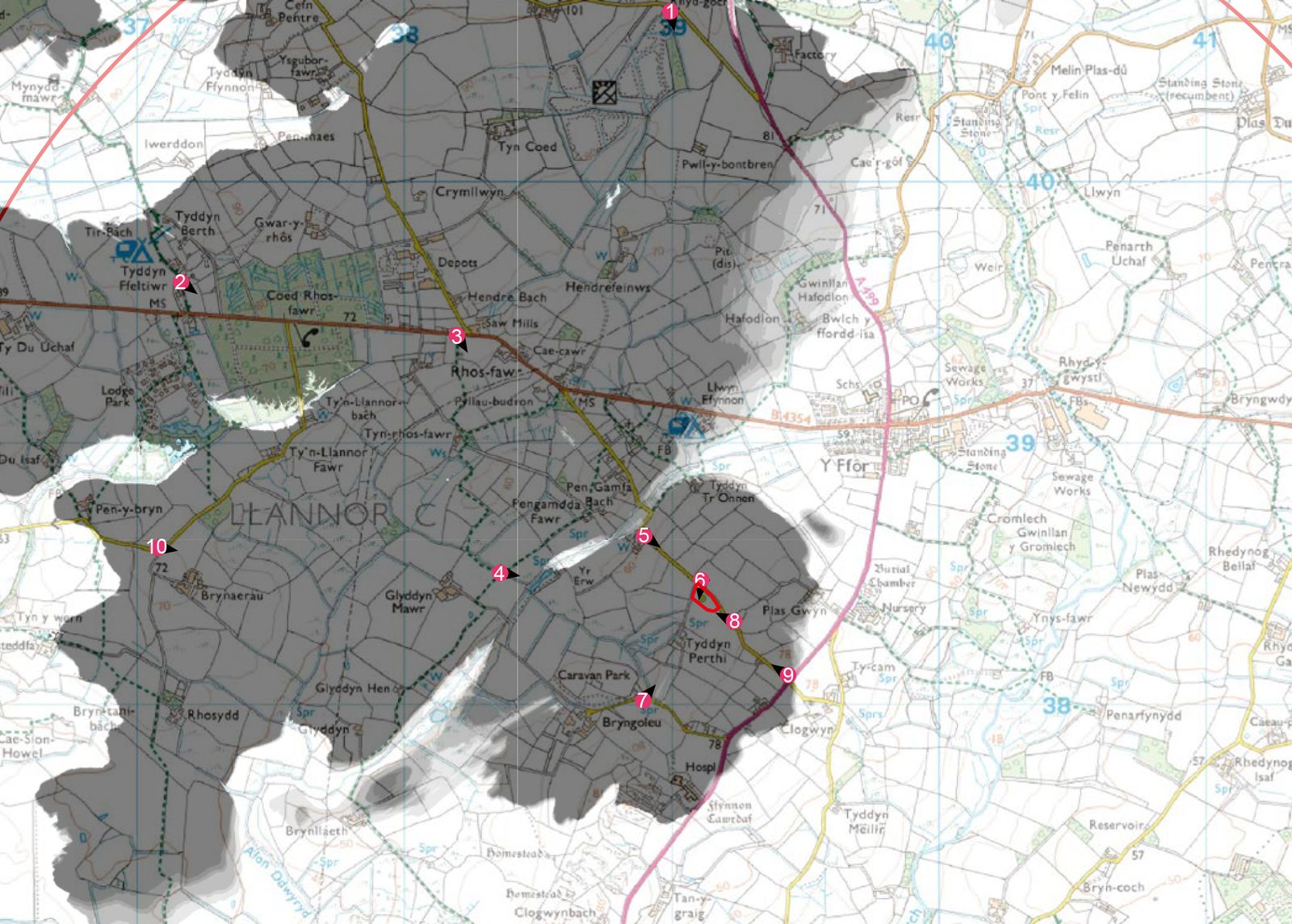
The visual baseline covered ten representative viewpoints around Rhosfawr, Y Ffor and the A499 corridor, including the restricted byway at Llwyn-dynys (PRoW Llannor 19), public footpaths PRoW Llannor 2 and 16, local rural roads around Rhosfawr and the A499 through the village. Of those ten, six returned no visibility of the site at all: dense roadside hedgerows, mature field boundaries, subtle landform and tree cover combined to screen the field completely from almost all the nearby rights of way. Meaningful visibility was limited to four positions close to the site on local roads and at the site entrance.
Our approach
The assessment approach pivoted on a point of legitimate context within the LCA. The wider Central Llŷn landscape already contains a number of small chalet and caravan groupings dispersed within similar field structures — meaning there is local precedent for low-density tourism accommodation of exactly this scale and character, provided the design reads as vernacular. The test, therefore, was whether this particular scheme could sit as a quiet addition to that precedent without compromising the historic legibility of the enclosure pattern, breaking the ridge skyline or disrupting the rural tranquillity that defines the area.
Mitigation and design response
The mitigation strategy was inseparable from the architectural approach. Lodges were designed as low-profile timber structures in muted tones that echo the rural vernacular, set informally in clusters interspersed with open space to mirror the dispersed grain of traditional farmsteads and outbuildings rather than the regimented rows of a conventional holiday park. Skylines and ridges were deliberately avoided. All existing boundary hedgerows and mature trees were retained, and a comprehensive structural planting framework of native hedgerow, shrub and tree species was introduced along the site edges and internally — restoring the visual rhythm of the traditional field pattern, reinforcing ecological corridors and progressively filtering views of the built elements. The existing site access was reused to avoid unnecessary ground disturbance.
The outcome
At the NLCA scale, effects were assessed as neutral at both Year 1 and Year 10, with landscape integrity fully maintained. Within LCA 10 Central Llŷn, the effect was slight adverse at Year 1 reducing to neutral by Year 10 as the native planting framework matured. At site level the effect was moderate adverse at Year 1, reflecting the honest reality of introducing built form into a previously undeveloped pasture, reducing to slight adverse at Year 10. Visually, the picture was closely contained: six of ten viewpoints showed no visibility, Viewpoint 6 at the site entrance reported moderate adverse effects at Year 1 reducing to slight adverse by Year 10, and the remaining visible viewpoints diminished to neutral. The overall conclusion was that, with sensitive design and the proposed mitigation measures, the residual landscape and visual effects of the scheme would not be detrimental to this sensitive historic landscape.
Working on a similar project?
If you are preparing a planning application that needs landscape and visual evidence — from a single dwelling to a major EIA scheme — we can help. Tell us about your site and we will respond with a fixed fee and programme within one working day.